Tacoma’s topography is no joke. You’ve got steep coastal bluffs along Commencement Bay, deep ravines carved by glacial meltwater, and wet winters that saturate everything. We keep seeing the same pattern: a developer buys a lot with a view, only to discover the slope beneath it is a slow-moving landslide complex. That’s where a proper slope stability analysis comes in. Our team has worked sites from Browns Point to the Nalley Valley, and the soil profile rarely matches what the county GIS maps suggest. Before you stake a foundation, you need to understand what’s holding that slope together—because in Tacoma, it’s often less than you think. When we combine in-situ permeability testing with deep borings, the picture gets much clearer, especially in the Vashon till and advance outwash deposits that dominate the city.
In Tacoma, a slope doesn’t fail when you build on it—it fails three winters later, when the groundwater finally reaches the critical layer.
Service characteristics in Tacoma
Demonstration video
Critical ground factors in Tacoma
Tacoma sits at roughly 47.24°N latitude, right in the path of Pacific storm systems that deliver 40 inches of rain annually. That’s not just a weather statistic—it’s the primary trigger for slope instability in the city. The 1949 Olympia earthquake (magnitude 7.1) and the 2001 Nisqually earthquake (6.8) both caused landslides along the Tacoma waterfront bluffs, and the geologic record shows repeated prehistoric failures in the same corridors. If you’re developing near Ruston Way or the Schuster Parkway slope, you’re building on ground that has failed before. A rigorous slope stability analysis isn’t optional here—it’s the only way to satisfy IBC Chapter 18 and avoid a stop-work order from the City of Tacoma’s building department. We’ve seen retaining walls tilt and foundations crack when the analysis underestimated the depth of the failure surface by just a few feet.
Our services
Our slope stability work in Tacoma typically involves a phased approach: first the field investigation, then the analysis and design recommendations. We tailor the scope to the site—a small residential lot in the North End gets a different investigation than a commercial excavation in the Dome District.
Geotechnical Drilling & Instrumentation
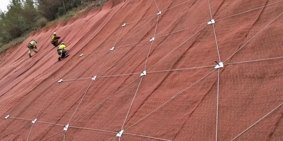
We mobilize track-mounted or limited-access drill rigs to advance borings through the Vashon till and into the underlying advance outwash. Piezometers and inclinometers are installed where groundwater or movement monitoring is required.
Stability Modeling & Mitigation Design
Using GeoStudio (SLOPE/W + SEEP/W) or PLAXIS, we model cross-sections through the critical slope face. Deliverables include factor of safety calculations, slip surface geometry, and conceptual mitigation—soil nailing, tieback anchors, drainage, or regrading.
Quick answers
What does a slope stability analysis cost for a typical Tacoma residential lot?
For a single-family residential slope evaluation in Tacoma—including a site visit, two to three exploratory borings with SPT sampling, laboratory shear strength testing, and a stability report with recommendations—the cost typically ranges from US$1,250 to US$3,890. The final figure depends on access constraints, slope height, and whether instrumentation like piezometers is required.
How deep do you need to drill for a slope stability analysis on Tacoma’s coastal bluffs?
We typically extend borings at least 1.5 times the slope height below the toe, or until we hit competent material. On Tacoma’s bluffs, that often means drilling 40 to 80 feet to penetrate the Vashon advance outwash and reach the Kitsap Formation or older glacial sediments. The critical failure surface on a 60-foot bluff is rarely shallower than 30 feet.
Does the City of Tacoma require a geotechnical report for slope construction?
Yes. Under IBC Chapter 18 and Tacoma Municipal Code, any construction within a mapped landslide hazard area or on slopes steeper than 15% requires a geotechnical report signed by a licensed engineer. The report must include a slope stability analysis with static and seismic conditions, and the building permit will not be issued without it.